
Although many of the articles I researched and wrote for the Canadian Forest Service’s Pacific Forestry Centre are posted on this blog, the entire collection is published in the centre’s science and technology bulletin, Information Forestry.
Information Forestry, December 2012—
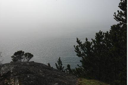
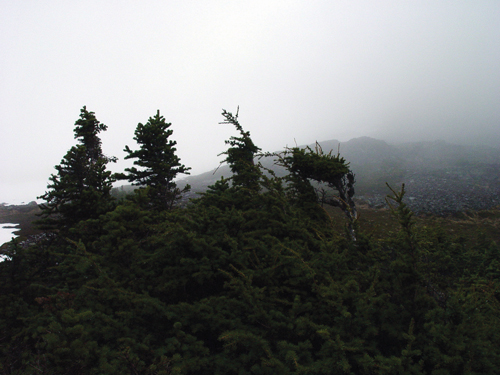
British Columbia is home to some of Canada’s highest-elevation forests. In the very highest of these—growing at treeline in or near the true alpine—evergreens hug the ground, twisted and bent by wind and snow pack, with vertical leaders repeatedly pruned by severe winter temperatures, ice, and wind. Many models that predict how changing climate will affect species distribution assume temperature limits both growth and spread of these forests. As global temperatures rise with climate change, these models forecast the forests will straighten, grow tall, and colonize ever-higher slopes.
However, a recent study by Natural Resources Canada Research Scientist Eliot McIntire suggests these assumptions need re-examination. McIntire and colleague Alex Fajardo, of the University of Montana, tracked growth at high-altitude treelines in the Chilean Andes and Montana’s Rocky Mountains. Basal tree cores at the sites show tree growth and colonization up the slopes improved for most of the past 200 to 300 years. This corresponds to a period when global temperatures were just beginning to climb to today’s levels out of the very coldest decades of the last millennium.
“Synchrony between temperature and growth and temperature and recruitment clearly occurred during that period in both regions,” says McIntire. “Then, during the past half-century, it was lost at all sites.”
In fact, any improvements in growth that had occurred have since disappeared or reversed.
This decoupling of temperature and high-altitude growth and recruitment rates may indicate that the world is entering a period in which temperature no longer drives growth and colonization at treelines, McIntire says. Other factors, such as availability of water, may now be the main constraints.
The findings suggest climate models may need to be modified to separate high-altitude growth and recruitment drivers if they are to capture what is really going on under British Columbia’s—and the world’s—highest forest canopies.
© Natural Resources Canada 2013
Information Forestry, December 2012—The biggest challenge in forecasting fire-season resource needs in Canada, says Canadian Forest Service Forest Inventory and Analysis Research Scientist Steen Magnussen, is the variability in the country’s fire regimes.
“The environment, the size of Canada, the weather, the forest structure, larger climate patterns, the fire danger—all that combines to create the variability that we face year to year, location to location,” he says. “That’s why it is so difficult to predict how many resources are going to be needed anywhere and at any one time across the country.”
Borrowing methodologies from the insurance industry, Magnussen has developed a statistical framework that captures the variability and other key characteristics of Canada’s fire regimes on a weekly basis. The framework enabled him and Natural Resources Canada Fire Officer Steve Taylor to estimate how fire events in Canada are distributed in relation to one another across and between 48 regions and throughout a fire season.
“Resource sharing works because we don’t usually get major fires occurring in different regions at the same time,” Magnussen says. “We wanted to see if that pattern is stable enough that we could do estimates of likelihood: What is the probability of one, two, three provinces experiencing peaks in fire activity at one time?”
The resulting fire-event distribution revealed that, in recent decades, Ontario’s fire numbers tend to peak in spring, after snowmelt but before the forest greens up. British Columbia’s fire season usually peaks later in the summer—after drought sets in—as happened with the 2003 Kelowna fire.
“This lack of synchrony is essential,” Taylor says. “How many regions aren’t experiencing fire-occurrence peaks when other regions are? And which regions? Not all jurisdictions have the same amount of resources. For resource sharing to work, it’s important to track synchrony and asynchrony with regard to those resource-wealthy regions.”
The study is the first step in a project Taylor is leading to determine possible effects of climate change on future fire-resource sharing. “We needed to assess the current situation: What are the chances of peak overlap occurring between jurisdictions now?”
One of the questions Taylor and Magnussen wanted to answer was whether daily, weekly, or biweekly patterns in historical use of fire-fighting resources exist. The amount of data on resource use exists only for the last 25 years, and even that is inconsistent and in some places non-existent.
“Most fire-management agencies don’t track number of firefighters or number of person days,” Taylor says. “They can tell you what was used through a season, but not on a day-by-day basis. Even for a particular fire, it can be hard to find that information.”
With fire patterns and the statistical joint distribution of fire events now mapped and established in time and space, fire managers can use the system created by Magnussen to determine the likelihood of various fireevent scenarios across the country. And when resource-needs information for individual fires becomes available, the system will enable fire managers and researchers to quantify opportunities for and constraints on sharing resources across jurisdictions.
© Natural Resources Canada 2012
Information Forestry, December 2009—

International sanctions by countries in Europe and Asia target the trade and transport of North American wood that may be infected with pinewood nematode, the cause of pine wilt disease.
A new molecular diagnostics method developed by Natural Resources Canada to detect live pinewood nematode in wood caught the attention of forest health officials from around the world.
“Scientists from countries with forests infested by pinewood nematode expressed a great deal of interest, as did those who are developing phytosanitary treatments,” says Canadian Forest Service Research Scientist Eric Allen, who presented the method’s preliminary results at the 2009 International Symposium on Pine Wilt Disease in Nanjing.
Pinewood nematode is the microscopic roundworm that causes pine wilt disease. Native to North America, pinewood nematode rarely, if ever, affects North American tree species. However, it has caused serious damage in Asia and Portugal prompting quarantine regulations by concerned countries. In 1993, Europe banned imports of untreated softwood commodities from North America, resulting in significant decreases in markets.
The new detection method, developed by Canadian Forest Service Molecular Biologist Isabel Leal and colleagues, allows forest health officials to analyse wood samples for messenger-RNA associated with pinewood nematode heat-shock proteins. Unlike DNA, which can survive in dead tissues for years, mRNA degrades after an organism dies. Its absence indicates lack of viable nematodes in a sample.
“It’s important to have a method to differentiate between deal and live nematodes, because only live nematodes are a risk to forest health,” says Leal.
Many major wood-importing countries, including China, Korea and Europe, require all softwood commodities exported from countries where pinewood nematode is found be treated prior to export with heat according to international standards. Leal and colleagues’ method will allow plant health officials to test and verify the effectiveness of treatments against the damaging nematode.
The method will also protect trade, by allowing exporters to demonstrate that their softwood lumber, chips, logs, prefabricated housing and wood packaging is free of living nematodes.
© Natural Resources Canada 2009
Information Forestry, December 2009 —

In 2009, Vancouver’s renowned Stanley Park was discovered to be home to 31 invasive moth species, four of which were identified in British Columbia for the first time. Photo by outdoor PDK.
Emerging DNA-screening technologies can play a vital role in detecting and identifying potentially problematic pest insects in Canadian forests, according to a recent insect survey conducted in Vancouver’s Stanley Park by Natural Resources Canada, the University of British Columbia and other agencies. In the survey, DNA screening uncovered 31 non-native moth species established in the 120-year-old urban park.
Four of the non-native species were not previously known to be established in British Columbia; three of those four are new records for North America.
“These are phenomenal results, considering only 190 species were collected,” says Natural Resources Canada Research Scientist Lee Humble. “The DNA analyses helped us zero in on species identities.”
Humble has been conducting surveys for alien insects in forested areas throughout British Columbia’s lower mainland for 14 years. In 2007, in cooperation with the University of British Columbia forestry department, the Metro Vancouver Parks Board and the Canadian Food Inspection Agency, he extended his research to include Stanley Park. Humble supplied light traps for the university-led insect inventory and developed protocols for collecting moths using light at sampling locations in the 400-hectare urban park. The park survey was initiated after the December 2006 windstorm toppled old-growth trees and caused more than $12 Million of damage to the park’s forests.

Damage by wind storm to the old-growth forests of Vancouver’s Stanley Park in 2007 prompted a survey for insects, which were identified using DNA-barcode screening. Photo by Jenny Lee Silver
Humble and Ph.D. candidate Jeremy deWaard used the survey to populate the DNA database of Canadian Lepidoptera for the Canadian Barcode of Life project, an initiative based out of the University of Guelph, in Ontario. Like the universal product codes on supermarket goods, the DNA segments that are analysed serve as species-specific identification tags that eventually could be cross referenced between the database and new samples collected in the field to assist with species detection and identification, track movement of species around the globe, and study evolution and biodiversity.
“The Stanley Park experience highlights many advantages to using barcoding in biodiversity inventories,” says deWaard, who contributed to development of DNA-barcoding methodology during his undergraduate and masters studies at Guelph.
DNA-barcode screening increased the accuracy of species identifications and speeded up the identification process to a matter hours per specimen compared to days or weeks using traditional methods. It also flagged specimens requiring further attention, thereby allowing trained taxonomists to focus on problematic identifications while non-specialists were able to confirm identities of the common, routine specimens.
“It allowed us to identify cryptic species, new species, species that don’t belong here, and species for which only single specimens were collected.”
For instance, DNA analysis of one lone specimen collected in the park indicated the moth closely matched the genus Prays from Eurasia.

Prays fraxinella, an invasive moth from Eurasia, found in Vancouver’s Stanley Park, thanks to DNA barcoding. Photo by oldbilluk.
“So right away we knew the family and had an indication of genus,” deWaard says. “In a quick discussion with colleagues, we learned of one specimen that had been collected in Newfoundland in the 1970s that was also a member of Prays, so we pieced it together, looked at the literature and examined our single Stanley Park specimen, and that’s how we arrived at the i.d.”
Prays fraxinella is one of the four survey identifications that represent new non-native moth records for British Columbia.
“The Stanley Park results demonstrate clearly how DNA screening can save time and resources, and provide reliable, accurate identification,” says Humble. “As the technology becomes more accessible and cost-effective, we’re going to see DNA screening become a regular part of the pest detection and monitoring toolkit.”
© Natural Resources Canada 2009
Information Forestry, August 2008—Orbiting the Earth more than 700 kilometres above Canada’s forests, a set of satellite-borne sensors collects data from the light reflecting off the planet’s surface.
Beneath the canopy of an eastern Ontario woodland, a Blackburnian Warbler prepares to fly south for the winter.
Linking these two phenomena is Biodiversity Monitoring from Space, or BioSpace, a Natural Resources Canada-led project that uses satellite-derived data to track key indicators of biological diversity over time.
BioSpace is the first system of its kind in Canada to use Earth observation data to monitor biodiversity over large areas in a systematic and repeatable manner. Its developers hope it will come to serve as an early warning system to alert governments and resource managers to critical habitat losses and areas with potential species at risk in even the most remote, inaccessible regions of the country.
“Most of the current work used to characterize biodiversity in Canada is very detailed and locally specific, and usually involves someone going out into the field and inventorying specific species,” says project leader Mike Wulder, a research scientist with Natural Resources Canada. “With BioSpace, we’re exploring the big picture: can we use Earth observation data from space to characterize national trends in biodiversity and identify locations where changes in certain conditions may indicate changes in biodiversity?”
BioSpace monitors four key indicators of biodiversity on the landscape, at one-kilometre spatial resolution. Topography drives climate. Land cover indicates types of cover (both vegetated and non-vegetated) and their spatial arrangement. The dynamic habitat index incorporates measures of annual vegetation productivity or greenness, amount of snow cover in winter, and seasonal variation in landscape greenness (an indication of when food is available). The fourth indicator is disturbance of land cover over time.
The BioSpace team recently compared indicator-based predictions of biodiversity to field data collected for birds, such as the Blackburnian Warbler, by the Ontario Breeding Bird Survey and on butterflies in the northeastern U.S.
“Land cover and seasonality are the two remotely sensed indicators that explain most variations in species richness for these two groups,” says Nicholas Coops, University of British Columbia Associate Professor of Forest Resources Management, Canada Research Chair in Remote Sensing, and a member of the BioSpace team. “Birds and butterflies like edge environments: they might live in one habitat, breed in another, and feed in a third. If you’re interested in using BioSpace to monitor the status of bird populations, you would focus on these two indices.”
“It’s very expensive to go out and monitor every single species at risk,” says Natural Resources Canada Biodiversity Science Advisor Brenda McAfee. “We don’t have the resources to do that even in the regions that have roads and easy access, let alone in remote regions of the country that have no roads or transportation infrastructure.” BioSpace, she says, would permit her group to report on biodiversity on an ecosystem or landscape level anywhere in Canada. Agreements requiring reports on biodiversity include the Convention on Biological Diversity, the Montreal Protocol’s Criteria and Indicators of Sustainable Forest Management, the Canadian Biodiversity Strategy, and the National Forest Inventory.
In addition, information generated from BioSpace allows researchers and natural resource managers to prioritize field sampling. “BioSpace is not a substitute for field sampling,” says Wulder. “You have to have boots on the ground in order to actually inventory the species and conditions.” BioSpace may facilitate allocation of scarce resources for detailed field studies and species-at-risk conservation.
BioSpace is supported by the Government Related Initiatives Program (GRIP) of the Canadian Space Agency.
“The development of a Canadian dynamic habitat index using multi-temporal satellite estimates of canopy light absorbance” and “Development of a large area biodiversity monitoring system drive by remote sensing” can be ordered from the Canadian Forest Service online bookstore.
Captions:
From the Cover: ist2_3765025-blackburnian-warbler-with-insect: Fragmented forests and woodlands make for important bird and butterfly habitat, according to a recent comparison of indicator-based predictions of biodiversity to field data. credit: © Paul Tessier, istock 2007
© Natural Resources Canada
Information Forestry, April 2008 — In order to measure a disease’s impact on a tree, you need to know when it became infected. This is difficult to do with root diseases: infection and disease progression occur underground, and above-ground symptoms may not show until years later, if ever. As well, root diseases progress through a stand with time of infections varying between trees.
Natural Resources Canada Root Diseases Research Scientist Mike Cruickshank recently determined how to date infections by root-rot fungus Armillaria ostoyae years after they occur.
His method traces a defense mechanism that occurs in most trees. When a tree is wounded or stressed, ducts called traumatic resin canals form under the tree’s cambium and around the affected tissue. If enough develop, the canals create a physical barrier between affected and healthy tissues. The barrier helps contain the infection.

Traumatic resin canal barriers form beneath a tree’s cambium layer in response to fungus infection. By tracing the canal positions preserved within tree rings to nearby lesions, researchers can determine when past infection events occurred.
The canals are preserved within the annual rings of root wood, which is how Cruickshank is able to trace them across the rings to specific fungus-caused lesions.
“Traumatic resin canals allow us to create a profile of infection events over time,” he says. If attacked once, a tree may contain an infection with canals, but the fungus may grow around the edges of the resin barrier and attack the roots elsewhere. “Being able to date infection events by year means we can go back and determine impacts of that particular infection—on growth and production in the tree, as well as subsequent effects in the stand.”
Knowing root disease impact would enable forest managers to more accurately predict future timber supply from high-risk stands, as well as to assess broader economic, silviculture, and climate change impacts.
Root diseases exist in most forests, but are especially common in tree plantations, particularly those where stumps of previously harvested trees are left in place before replanting.
Armillaria attacks the roots of all trees and many shrub and herb species native to British Columbia, but causes greatest mortality among Douglas-fir trees planted in the province’s interior. The fungus is prevalent across Canada and the northern hemisphere.
© Natural Resources Canada 2008
Information Forestry, December 2007—Many insects rely on scent to communicate with each other and to find food and hosts. Setting out traps baited with insect and host-tree smells has long been a technique used by plant health officials to detect and track unwanted pests.
But the scents currently used by the Canadian Food Inspection Agency (CFIA), the federal organization responsible for keeping Canada’s forests safe from alien forest pests, fail to entice all insects of potential concern into detection traps. For instance, baited traps have yet to consistently capture emerald ash borer or Asian longhorned beetle, two non-native insect species infesting regions of southern Ontario. Scientists at Natural Resources Canada are helping the CFIA close these gaps by testing new lures and scent combinations.
“Right now, we’re quantifying what species the lures are picking up and what species they’re missing,” says Canadian Forest Service Entomologist Lee Humble, from the Pacific Forestry Centre. “Our goal is to develop more generic lures and extend the repertoire of lures used to trap nonnative insects that may have already become established in Canada.”

Plant-protection officials set out insect traps baited with scents that attract beetle and moth species to detect and monitor the presence of forest pests. Canadian Forest Service researchers are trying to determine the most effective scents and scent combinations to lure non-native wood-boring and bark beetles into traps.
The researchers are testing combinations of scents released by common host trees, in addition to insect pheromones—scents released by insects that prompt behaviours in other members of the same species.
“Pheromones target specific species or groups of species, and are usually much more sensitive than host-tree compounds,” says Atlantic Forestry Centre Research Scientist Jon Sweeney. “A target insect encounters it, and it responds like, ‘hey, there’s one of me out there calling, and it’s saying let’s get together.’”
But pheromones limit the range of insects detected. “By including a pheromone in your trapping system, you increase sensitivity or detection ability for a particular pest, but you also narrow the focus of that lure,” Sweeney says. “It simply won’t work on a broader range of species.”
“There are hundreds or thousands of insects we don’t want entering this country,” says Peter deGroot, a research scientist with Great Lakes Forestry Centre. “You can put species-specific pheromones out, but it becomes very cumbersome to place and maintain hundreds of traps, each with a different pheromone for a different insect. And in many cases, we don’t have the pheromones, and we have to rely on other things to attract the insect into an area and into a trap.”
Lures based on tree scents, which include ethanol and components of turpentine, entice broader ranges of insect species by mimicking stressed or injured trees—the preferred targets of most wood- and bark-boring insects.
“Determining a suite of lures that attracts a broad range of species is a way to lower the risk of infestation by a non-native pest,” says deGroot. “It helps us find and counter insect problems before they blow up so big we can’t eradicate them.”
Humble, Sweeney and deGroot began testing in 2006. They placed lures at sites in Nova Scotia, Vancouver and southern Ontario that are considered high risk for introductions of alien forest insects. Sites include ports, freight depots, and warehouses. The scientists are documenting and analyzing results collected during the last two years, and will be setting out test traps again in 2008.
© Natural Resources Canada 2007


