Cellphone driver. Photo © James Legans, Jr., creative commons

A century ago, people who drove automobiles unsafely on city streets were called jay-drivers. Like Toad of Toad Hall from the children’s book, Wind in the Willows, they wandered all over the road, drove too fast or drove too slow, stopped and started unpredictably, and caused mayhem—and consternation—among other road users.

Jay-driver was an insult. “Jay” meant rube, or an uneducated, unsophisticated person, someone so caught up in looking at the sights, they obliviously endangered others.

Today, jay drivers often are DUI or DUD (driving while using devices). And we call them something else altogether other than jay-drivers. Occasionally, we call the cops, too….

Read the rest of this editorial at the Victoria Times Colonist…. 

Kananaskis Country in winter. Photo by Brian Uhreen, http://www.flickr.com/photos/snype451/5644810651/

Although weather in Alberta’s mountains can be counted on to be unpredictable, when it’s sunny, it’s glorious. Photo by Brian Uhreen

Explore Kananaskis, Winter/Spring 1997Covering more than 5,000 square kilometres, Alberta’s Kananaskis Country encompasses everything from foothills in the east to the rock, alpine Continental Divide in the west, from the wide, windswept Bow River Valley in the north to narrow passes and valleys in the south.

With such variety in terrain, elevation and exposure, one of the few things you can count on regarding weather in the wilderness region is that is it unpredictable. The adage, “If you don’t like the weather, wait five minutes,” applies.

Winter – generally

Winter in Kananaskis starts in November and lasts until March. Unless it starts in September. Or ends in May. There are years when an early drop in seasonal temperatures lowers the snow line soon after Labour Day. There are as many years when winter blasts on and on until June, at which time summer arrives, bypassing spring altogether.

Duelling weather systems

Kananaskis Country generally has two continental weather systems in play during winter. Frigid, dry Arctic systems from north or east blow without resistance over the prairie until they smack into the Rocky Mountains. These ramparts of stone funnel and deflect the air-flow southward. The arrival of these systems usually means cold temperatures and ice crystals in the air. These systems can also dump snow in the foothills while bypassing points further west.

Contrast that with the Pacific weather that blows in from the west coast. These systems tend to be warmer than Arctic systems, and are laden with moisture that falls as rain in Vancouver and turns to snow as they are forced up the staircase of mountain ranges across British Columbia. By the time the systems arrive at Alberta’s western reaches, the majority of the moisture has already condensed into clouds and precipitated out on the western side of the Continental Divide.

The amount of snow lessens the further east a wintertime Pacific system extends. Thus, West Bragg Creek, on Kananaskis Country’s east side, receives less snow from these systems than does Peter Lougheed Provincial Park, abutting the Continental Divide to the west.

Elevation effects

Cross-country skiing, in Kananaskis Country. Adam Kahtava photo - http://www.flickr.com/photos/kahtava/5213943879/

Kananaskis Country is home to some of the best cross-country skiing in Canada. Photo by Adam Kahtava.

Elevation influences the differences in snowfall and accumulation between east and west Kananaskis Country. The higher you go, the colder it gets, the more likely that what precipitation there is will fall as snow, not rain. Snow accumulates; rain does not.

However, to every rule, there is an exception. Although higher elevations usually do mean lower temperatures, diehard winter outdoor enthusiasts have been known to leave Calgary where it is –35° C and spend a sunny day on Peter Lougheed Provincial Park trails in balmy –10° C temperatures. This winter phenomenon is called temperature inversion, and occurs frequently in this part of the world. Arctic high-pressure systems spread a thin layer of cold, murky and sometimes polluted air over the prairies and foothills valleys. One of the warmer western systems—as much as 15° C warmer—sits above it, trapping the cold air below.

To find out when to take advantage of a temperature inversion, compare Environment Canada’s Calgary forecast to its Banff forecast. If it’s warmer in Banff, temperature inversion is occurring.


Chinooks: spring in February

Chinook Arch at Sunset. Photo by Tuchodi, http://www.flickr.com/photos/tuchodi/5381184500/

Chinook Arch at Sunset. Photo by Tuchodi

East–west differences in snow accumulation can also be affected by recurring Chinook winds. Chinooks are a distinctive part of the Pacific weather system: as many as 10 times each winter, they blow in from the west, gradually chilling and dumping snow as they climb the British Columbia mountain staircase. With one final dump on the Continental Divide, a now-near-dry Chinook wind flows down the mountains to the plains, skipping over the Rocky Mountain front ranges and foothills like a rock skipping over water. As the wind descends, its temperatures rise faster than they had cooled on the ascent. Somewhere over the eastern edge of the front ranges, the Chinook encounters a very cold, Arctic high-pressure system locking the prairies in its frigid grip. What moisture remains in the Pacific systems condenses, forming a distinct arch of cloud along the line of the mountains.

The Chinook Arch announces a dramatic reprieve from winter. Temperatures can rocket from –30° C to +10° C in a matter of hours. Snow vanishes. Gutters fill. Spirits rise. Calgarians go home in the shirtsleeves, lugging parkas in their arms. Elk and deer, and antelope on the prairies further east, can feed and move about easily again.

Points west in Kananaskis Country tend to be frequently skipped over by Chinooks. Although these winds do occur in Peter Lougheed Park and the Spray River Valley, they tend to be weaker and more ephemeral there. The Bow River Valley sees the most Chinooks of all of Kananaskis, often serving to funnel them east out of the mountains and onto the plains.


cover-pachyrhinosaurus-by-monique-keiran

book-ornithomimus-by-monique-keiran

Sample pages from Ornithomimus: Pursuing the Bird-Mimic Dinosaur, by Monique Keiran. Published by the Royal Tyrrell Museum of Palaeontology and Raincoast Books, 2002.

Trackways #19, Winter 1999: For years, when Royal Tyrrell Museum of Palaeontology technician Darren Tanke prospected in Dinosaur Provincial Park, he searched only for fossil bone eroding out of the ground. But, for a period in the late-1990s, he also looked for less likely treasure: old newspaper, dried clumps of plaster, tin cans and burlap… traces left by palaeontologists who collected fossils in the park during the 1920s and earlier.

Tanke was trying to locate historic quarries. From 1995, when he started his quest, to 1999, he had verified eight mystery quarries, using old garbage, archival photographs, field notes, and old letters to date excavation, identify who did the collecting, and what was collected.

“We found the quarry-location map made in 1950 is incomplete and somewhat inaccurate,” he says. “On top of that, palaeontologists started quarry-staking excavation sites in the park only in 1935, and locations excavated earlier are poorly described: ’10 miles below Steveville’ is a lot of territory in the badlands.”

Quarries are staked when palaeontologists cement a steel pipe into the floor of their quarries. A disk welded to the rod identified who collected what and when. In 1999, there were about 230 staked quarries in the park, leaving Tanke with the task of trying to find and identify another 150 to 2000 unmarked quarries.

Apart from their historical significance, accurate quarry records help today’s palaeontologists determine what dinosaurs are associated with which layers of rock. They also help scientists match new fossil material discovered in old quarries to incomplete specimens collected years ago.

Legacy: Alberta’s Heritage Magazine, May–June 1999—

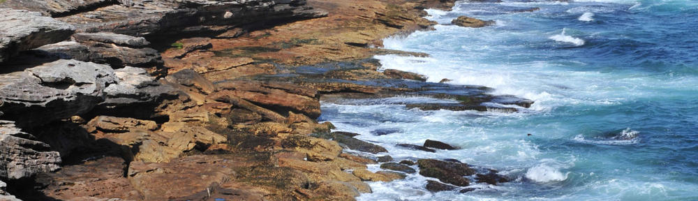
It is a sudden thing and takes you by surprise. As you follow the long curve in Highway 9 northeast of Calgary, the immense, rolling prairie breaks on the left, opening into a narrow valley, worn by weather and softened by summer colours.

You have time only to glance before it is gone from sight.

The appearance of Horseshoe Canyon is so sudden and so unexpected, it rates as one of the most spectacular introductions to Alberta’s badlands. Seventeen kilometres east of Drumheller, Horseshoe Canyon is often a visitor’s first glimpse of this bizarre and haunting landscape.

A roadside recreation area was meant to accommodate those who stop to look, but tourists had overrun the adjacent field. Just a few years ago, the landowners were so frustrated with the damage, they considered selling the site to a golf course developer.

Along came Leila Nodwell. To change the Horseshoe Canyon experience, Nodwell and her son built and opened the Horseshoe Canyon Interpretive Centre in 1997. For one summer, they ran bus tours into the canyon on a leased half-section of land beyond the recreation area. What started out as a market for their family-built glacier tour buses turned into a passion and a dream for Nodwell. When the buses proved unviable, she remained, bewitched in a way, by the site’s eerie beauty. She committed to preserving and sharing it with visitors.

“It’s a very special place. These are the first badlands people encounter on their way out from the city, and they make such an impression. Ther was so much potential here for educating people, having them experience the badlands and making them care.”

Access to the land is free, but Nodwell provides additional opportunities for visitors to explore it and, in particular, given visitors who would otherwise be unable to experience the badlands the chance to travel within them.

“I love grandfathers who bring their grandchildren,” says Nodwell. “Many grandpas can’t walk into the canyon with the kids, but they can drive. And they can do something exciting and interesting together. It gives them adventure and something they can learn about together.”

The all-terrain buggies that visitors now drive into the canyon have been adapted by engineers especially for the site, have seats for eight people, and include an audio tour and printed information about points of interest along the way. Starting this summer, visitors can also sign up for guided hikes of the canyon. The preserve the area, Nodwell asks visitors to sign an agreement that they will not take anything form the site or damage the fragile badlands by driving buggies off-road or hiking off designated paths.

Preservation is one of Nodwell’s biggest concerns. Another is that nobody will listen or care. She faces everything from bureaucracy and red tape to the sometimes agonizingly slow process of developing awareness among local residents and visitors. She is exploring partnerships with like-minded agencies to help protect the site—the western chapter of the Nature Conservancy of Canada has expressed interest—and is even investigating World Heritage Site designation by the United Nations.

With little background in ecology, geology, or tourism management, Nodwell is learning as she goes. In three years, she has learned about prairies and badlands, their formation throughout geological history, and the plants and creatures that call them home. She has studied the human history of the area and is acquiring knowledge and experience necessary to manage and market a conservation and ecotourism venture.

Partnerships are a vital part of her strategy and the centre’s development. Near the interpretive centre stands a tipi made and painted by a family from southern Alberta’s Siksika Blackfoot Nation. Its presence highlights use of Horseshoe Canyon by First Nations peoples prior to settlement of the area—archaeological sites on Nodwell’s half-section include a quarry and a hearth. Shortly after the tipi was erected, Nodwell and the family discussed it and its paintings. The resulting booklet is a available in the interpretive centre.

“There is such a hunger, especially among European visitors, for this kind of information. I though this would be a great way to tell of them of the First Nations presence here. It is such an important story and needs to be told,” she says.

Other partnerships assist with returning the weedy turf on the edge of the canyon to its former prairie glory. With a horticultural acquaintance, Nodwell researched prairie plants and planted native wildflowers around the interpretive centre’s foundations. Last spring, an agriculturalist volunteered time and expertise to sprout native grass seed donated by a southern Alberta company. Nodwell planted thousands of blue grams, rough fescue, little bluestem, spear and wheat grass in demonstration plots around the building. The new plants thrive next to the strip of transplanted, unploughed sod that was salvaged from the edge of the canyon before construction crews arrived to build the facilities in early 1997. Where canola and thistles bloomed three years ago, native wildflowers and grasses are reappearing as the Dry Land Wild Flower and Natural Grasses Exhibit. Nodwell hopes to, in time, have the site look like it did a century ago.

“You know what I’d like?” she asks. “When the project is finished, I’d like the garden to be on par with Victoria’s Butchart Gardens and draw people from all over the world just to look at the prairie flowers and grasses. This place could be a real showcasefor native prairie landscaping.”

The Horseshoe Canyon Interpretive Centre project itself could be a showcase for what a dream and a little passion can accomplish. Nodwell has, almost singlehandedly, transformed a site threatened by a golf course and heedless sightseers into a place where visitors can experience and learn about an important part of southern Alberta’s landscape and history.

Yes Mag: Canada’s Science Magazine for Kids, Winter 1998/1999—If a group of animals died together, there’s a good chance they lived together, says Philip Currie, dinosaur palaeontologist at the Royal Tyrrell Museum in Drumheller, Alberta.

Currie is studying a recently re-opened bonebed, located 60 kilometres up the Red Deer River from the museum. It contains the jumbled remains of Albertosaurus—a large, meat-eating dinosaur related to Tyrannosaurus rex.

Material from the site is changing scientists’ views on how the animals lived. Tyrannosaurs were though to be solitary creatures, but the Albertosaurus bonebed points to social behaviour. It appears that at some point in their lives the large carnivores were living in packs—possibly to hunt migrating herds of duckbilled and horned dinosaurs.

Although material from this site is giving scientists new ideas, this is not the first time the bonebed is being explored. In the 1910s, American palaeontologist Barnum Brown spent four summers collecting fossils from this area. Among the boxcar loads of bones he shipped to New York’s American Museum of Natural History were the remains of nine specimens from the Albertosaurus bonebed.

Brown’s field notes were sketchy, however. It wasn’t until Currie studied the New York specimens in 1996 that he realized the albertosaurs came from one quarry.

The following year, with only Brown’s notes and four archival photographs for direction, Currie searched for the site.

“We were trying to match landscapes with those in the photographs and were having no luck,” he says. “Another photograph was of the camp, taken from across the river. I sent someone over and they found the spot right away—it was that obvious. Now, it makes sense the quarry would close to the camp….”

After many more hours of searching, Currie found the quarry. “All that was left was a sinkhole, but there was lots of material. Pieces of skulls, toe bones, and bits of rib. It turns out Brown had excavated less than 25 percent of the site.”

Currie’s 1998 survey of the bonebed turned up pieces of a tenth individual dinosaur. What scientists find especially exciting is the diversity in the specimens’ ages.

“We found young guys. We found old guys. We found sub-adults,” says Stewart Wright, a palaeontology technician who works with Currie.

Scientists are still not sure why these dinosaurs died together. Charcoal in the rocks near the bonebed suggests a forest fire, but the evidence is inconclusive. Currie and his crew will return to the site next summer to look for answers.

cover-albertosaurus-by-monique-keiran